


Boundary Springs Trail: Where the Rogue River Begins
Trail report: A Southern Oregon hike through volcanic history, wildfire recovery, and the source of the Rogue River.
You can also watch the video at: https://youtu.be/PcS67jXuxpA

If you’re looking for a Southern Oregon hike that offers more than panoramic views, the Boundary Springs Trail is worth adding to your list. Located in the Upper Rogue River area, this trail takes you through a landscape shaped by an ancient volcanic eruption, a devastating forest fire, and thousands of years of flowing water. The destination is Boundary Springs, where groundwater emerges from a hillside and forms the beginnings of the Rogue River.
The springs are fascinating on their own, but what makes this hike especially memorable is everything you discover along the way. You’ll see how the forest is recovering from the 2015 National Creek Complex Fire, learn how rain and snowmelt travel through volcanic rock before emerging as springs, and gain a new appreciation for the natural forces that shaped this part of Oregon.
This is a hike for people who enjoy learning about the landscape as much as walking through it. Regular day hikers, occasional hikers, families with children accustomed to hiking, and Cub Scout, Webelos, and Scout troops can all find something worthwhile here, provided the group is prepared for the distance and current trail conditions.

Boundary Springs Trail at a glance
Location: Upper Rogue River area, Southern Oregon, near Crater Lake National Park
Trailhead: Mazama Viewpoint, off West Diamond Highway (Oregon State Route 230)
Distance: Just under 5.5 miles round trip
Elevation gain: Approximately 550 feet
Estimated hiking time: About 3 hours, depending on pace and stops
Main attraction: Boundary Springs, the source of the Rogue River
Other highlights: Smaller springs, the Rogue River, volcanic geology, and a forest recovering from wildfire
Best suited for: Day hikers, curious nature lovers, families with hiking experience, and organized youth hiking groups
Allow extra time if you enjoy photography, want to examine the springs, or plan to stop along the trail to discuss the geology and forest ecology.
Getting to the trailhead
Your hike begins at Mazama Viewpoint, off West Diamond Highway, also known as Oregon State Route 230. The trailhead is part of the Upper Rogue River trail area.

After setting out, you’ll hike for just over half a mile before reaching the junction marked for Boundary Springs. Turn left and follow the Boundary Springs Trail. From here, the Rogue River is frequently visible or audible as you make your way toward the headwaters.

The river is a companion for much of this part of the hike, but the destination is not a traditional mountain viewpoint. Instead, the reward is a chance to see water emerging directly from the volcanic hillside and beginning its journey downstream.
As with any hike in this region, check current trail and road conditions before setting out, particularly later in the year when weather can change quickly.
A forest still recovering from wildfire
One of the first things you’ll notice is that the forest doesn’t look the way you might expect.
In August 2015, the National Creek Complex Fire burned approximately 21,000 acres, affecting portions of the landscape around Boundary Springs. The fire killed many trees and left some areas marked by blackened trunks, dead standing trees, and fallen timber.
As you walk, you’ll encounter sections where the damage is still obvious. In other places, young trees and new vegetation are filling the spaces left by the lost forest canopy.
Some older trees survived, providing a reminder that a wildfire rarely affects every part of a landscape in exactly the same way.


The contrast can be striking. One area may look green and full of new growth, while another still appears severely burned.
Why does a burned forest recover unevenly?
The answer involves several factors.
Fire intensity: Some fires burn primarily through surface vegetation, while others kill many of the trees in their path. The more severe the damage, the more difficult recovery may become.
Seed availability: Surviving trees and nearby unburned forest can provide seeds for a new generation of trees. Where seed sources are limited, regeneration may take longer.
Water and weather: Young trees need sufficient moisture to become established. Conditions in the years following a fire can strongly influence how quickly vegetation returns.
The condition of the landscape: Soil conditions, the amount of surviving vegetation, and the arrangement of fallen trees and other plant material all influence what happens next.
As you explore the trail, you can see these differences for yourself. The landscape becomes an outdoor lesson in forest ecology, with different stages of recovery visible across the same general area.

But new growth doesn't mean the original forest has been fully restored. Mature trees, established vegetation, and the habitat associated with an older forest can take decades or longer to develop. Some severely burned areas may remain visibly changed for many years.
That is part of what makes this hike so interesting: you aren't looking at a finished landscape. You're seeing a forest in transition.
The volcanic history beneath your feet
The story of Boundary Springs goes back much further than the 2015 fire.
Approximately 7,700 years ago, the eruption and collapse of Mount Mazama created the caldera that now holds Crater Lake. The eruption spread enormous quantities of volcanic material across the surrounding region, including pumice deposits that profoundly changed the landscape.
Over time, rain and melting snow seeped into these porous volcanic deposits and fractured rock. Some of that water traveled underground before emerging at springs.
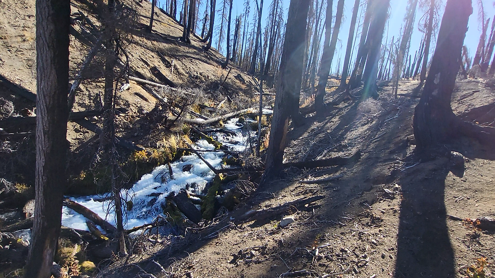
Meanwhile, water flowing over the surface gradually eroded the landscape. Over thousands of years, the Rogue River cut channels into the volcanic deposits, helping create the river valley and smaller canyons found in this region.
As you hike toward Boundary Springs, you're crossing a landscape shaped by both dramatic geological events and the slow, persistent work of water.
It's a useful reminder that the scenery around us is often the result of processes that began long before the forests and trails we see today.
Following the smaller springs to the source
After following the Boundary Springs Trail, you'll reach the spur marked for the springs. Turn left and follow the path alongside a small stream before the trail bends to the right toward the main spring.

The smaller stream is worth noticing. It is fed by another spring that contributes water to the Rogue River farther downstream. Depending on the season, its flow may be modest or much more impressive.
Spring snowmelt and rainfall can make these smaller watercourses especially interesting to observe. By late summer or fall, after the snow has melted and rainfall has been limited, the streams may look less dramatic.
Then you reach Boundary Springs itself.

Even in late October, the main spring was flowing strongly during this hike, despite the end of the snowmelt season and relatively little summer rainfall. The trail passes over the area where water emerges from the rocks, giving you a close look at the source of the Rogue River.
It's a surprisingly different experience from standing beside a large, established river. Here, you can see where the water begins to gather and flow.
Does Boundary Springs get its water from Crater Lake?
It's an understandable assumption. Crater Lake is nearby, and its enormous volume of water makes it an obvious candidate.
However, the springs are not simply outlets from Crater Lake. Their water comes from precipitation, including rain and winter snow, that enters the ground and moves through the volcanic deposits and underlying rock.
The porous geology provides pathways for water to travel underground before reappearing at the surface. Boundary Springs is one place where that underground journey becomes visible.
The spring's flow also demonstrates how much water can move through this landscape. At peak flow, the smaller springs can discharge approximately 600–900 gallons per minute, while the main spring can reach roughly 3,000–3,600 gallons per minute.

Those figures help put the scene into perspective. What looks like water quietly emerging from a hillside can produce a substantial and persistent flow.
After visiting the main spring, continue a little farther to see another smaller spring contributing to the Rogue River. It's worth completing this short extension before returning to spend more time at the main source.
Where the Rogue River begins its journey
Take a moment to sit near the spring and listen to the water.
A small sitting pad is a good idea if you want to rest on the ground or a downed tree. Some surfaces in the burned forest may leave soot on your clothing, so choose your spot carefully.
This is a good place to slow down and appreciate what you've found.
The Rogue River begins here as groundwater emerges from the volcanic hillside and gathers into a flowing stream. From this quiet setting, the river travels roughly 215 miles across Oregon before reaching the Pacific Ocean.
Along the way, it grows, cuts through canyons, passes forests and communities, and becomes the river familiar to anglers, boaters, rafters, and residents of Southern Oregon.
Standing at Boundary Springs, it's remarkable to think about that entire journey beginning with water emerging from the ground beneath your feet.
The destination also brings together the different stories you've encountered on the trail: the ancient eruption of Mount Mazama, the movement of water through volcanic rock, the forest that developed across the landscape, and the wildfire that changed it in 2015.
The springs are the destination, but the journey helps explain the landscape around them.
Is Boundary Springs a good hike for families and Scout troops?
Yes, for groups that are comfortable covering nearly 5.5 miles on foot and are prepared for changing trail conditions. This is particularly rewarding for hikers who like to learn as they go rather than simply walk toward a viewpoint.
Regular day hikers
If you hike regularly, Boundary Springs offers a manageable half-day outing with a distinctive destination. The elevation gain is moderate, and the variety of natural features gives you plenty to explore without committing to a full-day expedition.
Occasional hikers
Occasional hikers may enjoy this trail as a goal-oriented outing. The distance is substantial enough to require preparation, but the reward is more unusual than a typical overlook. Choose a comfortable pace, carry sufficient water and food, and leave time to return before conditions deteriorate.
Families with children
Families with children who are already accustomed to hiking can use this trail to introduce geology, rivers, and forest ecology in a real-world setting. Children can look for evidence of new growth, compare burned and recovering sections of forest, and observe the small streams feeding the Rogue River.
For younger hikers, the round-trip distance may be the biggest challenge. Plan regular breaks, bring snacks, and turn around if the group's energy or conditions warrant it. Keep children close around the springs, streams, and any uneven or slippery ground.
Cub Scouts, Webelos, and Scout troops
Boundary Springs can make an excellent outdoor learning destination for organized youth groups. Leaders can use the hike to discuss:
Geology: How volcanic eruptions changed the region around Crater Lake.
Water: How rain and snowmelt travel underground and emerge as springs.
Rivers: How small springs contribute to a river's flow.
Forest ecology: Why some trees survive wildfires and why recovery varies from one area to another.
Observation skills: How to record changes in vegetation, terrain, and water flow along a trail.
For organized groups, leaders should assess the abilities of the youngest participants, plan appropriate supervision, check current trail conditions, and establish a realistic turnaround time. Keep the group together and follow Leave No Trace practices.
The goal isn't simply to reach the spring. It's to help young hikers understand what they're seeing along the way.
What to know before you go
A few practical considerations will help make the hike more enjoyable.
Allow about three hours or more. The estimate assumes a reasonably steady pace. Photography, educational stops, and breaks will add time.
Bring water and snacks. Even a moderate hike requires preparation, particularly for children and groups.
Wear suitable footwear. Expect natural trail surfaces and be prepared for uneven ground and potentially slippery conditions.
Check seasonal conditions. Rain, snow, ice, and changing road conditions can affect access and hiking safety.
Respect the recovering forest. Avoid climbing on unstable dead trees or disturbing new vegetation.
Be careful near water. Rocks and stream edges can be slippery, and spring outlets may have uneven footing.
Pack out everything you bring. Keep the springs and surrounding landscape as undisturbed as possible.
The burned landscape is part of the trail's story, but it can also present hazards. Use good judgment, especially when hiking with children or a large group.
Final thoughts: A Southern Oregon hike with a story to tell

Boundary Springs is a great choice if you're looking for a Southern Oregon hiking experience that goes beyond scenic views.
What makes this trail special is the connection between the destination and everything you see along the way. The spring is fascinating, but so is the landscape that feeds it and the forest that continues to change around it.
If you've visited Boundary Springs, I'd love to hear about your experience. When did you hike the trail, and what did the forest look like when you were there? The landscape is still changing, so observations from different seasons and years can tell an interesting story.
For more Southern Oregon hiking trail reports, outdoor skills, and adventures exploring the natural world, visit Amputee Outdoors on YouTube and join me out on the trail.


Comments