Lower Table Rock Trail Report
- amputeeoutdoors
- 2 hours ago
- 3 min read
Length: 6.3 miles
Elevation Gain: 816 feet
Lower Table Rock is practically Medford’s backyard — about 12 miles out, maybe a 15–20 minute drive if you hit the lights right. Because it’s so close, and because the views of the Rogue Valley are ridiculous in the best way, it gets busy on weekends. But honestly, it’s short enough that you can knock it out after work in a couple hours once the heat backs off. Just toss a couple bottles of water in your pack; even in the evening this trail will dry you out faster than you expect.
I went up on June 18th, which around here basically means summer is in full “oven mode.” There are still a few stubborn wildflowers hanging on, but most of what you’ll see on the way up is that classic Rogue Valley khaki — dry grasses, dusty shrubs, and the kind of crunchy foliage that screams July even when it’s still June. Doesn’t matter though. The views still hit hard.
Right at the start you’ll see a couple of warnings. No dogs — and for good reason. The plateau is full of delicate plants and critters that don’t handle dog scent or paws very well. There’s also a reminder to brush off your boots so you’re not hauling in seeds from somewhere else. They even give you a little boot‑brushing station. Use it. It’s quick trail karma.

Bonus points: the trailhead has an actual bathroom. Not a port‑a‑potty. A real one. It’s the little things.
The trail starts paved, but only for about 200 yards. Then you hit the split: straight up toward the mesa, or right onto the Oak Savannah Loop — a mellow half‑mile detour. After that, it’s dirt and loose gravel the rest of the way. Heads up: that gravel gets a little sketchy on the descent, especially if your knees or balance aren’t in the mood to cooperate.

Most of the trail is in solid shape, but winter rains have chewed up a few sections. Some spots have lost their gravel layer entirely, leaving rougher rock underneath. Even with my prosthetic leg and hiking poles, I managed them just fine — just slowed down a bit and picked my line.
There are two benches on the way up. You don’t have to stop, but honestly? Take the break. Sit down, sip some water, listen to the birds, feel the breeze. Hiking isn’t a race — the journey is half the point.

After the second bench, the trail gets a little more serious. A couple switchbacks help you gain elevation, and every time the brush opens up, you get these teasing little glimpses of Upper Table Rock and Mt. McLoughlin. It’s like the trail is warming you up for the big reveal.
And then — boom — the plateau just appears. One minute you’re climbing beside a basalt outcrop, the next you slip past some brush and suddenly you’re standing on this wide, open mesa. A few social trails branch off, but stick to the main one to protect the plants and critters up there. There is a legit side trail to the left that takes you to the rim and loops back, but I was racing the heat, so I stayed on the main path.

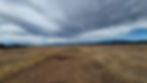
That long, straight stretch across the top? That’s the old airstrip from 1948. It never really took off — pun absolutely intended — and by the 1970s it was abandoned as the Table Rocks became protected. Now it’s just a weirdly straight line across the mesa, slowly fading back into nature.
At the end of that straightaway, the trail splits again. I went straight, found a comfy spot, and just sat for a while.
And wow. Totally worth it.
You get the whole Rogue Valley laid out in front of you — Roxy Ann, McLoughlin, the Siskiyous — all of it. I stayed longer than I meant to, and I’d do it again. In fact, I’m planning to come back in fall, winter, and spring just to see how the whole place transforms with the seasons.

If you haven’t done Lower Table Rock yet, or if it’s been a while, go. Seriously. Strongly recommend this one.
This Lower Table Rock Trail Report will be uploaded as a video in the next couple of weeks. Keep an eye out for it on YouTube on the Amputee Outdoors channel: https://www.youtube.com/@amputeeoutdoors